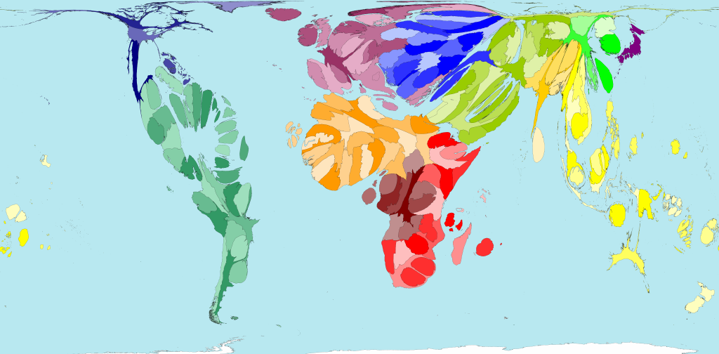
The following territories are shown in the map above: Central Africa : Angola , Burundi , Central African Republic , Congo , Democratic Republic of Congo, Equatorial Guinea , Gabon , Rwanda , Sao Tome & Principe, and Zambia . South Eastern Africa : Botswana , Comoros , Djibouti , Eritrea , Ethiopia , Kenya , Lesotho , Madagascar , Malawi , Mauritius , Mozambique , Namibia , Seychelles , Somalia , South Africa , Swaziland , Uganda , United Republic of Tanzania , and Zimbabwe . Northern Africa : Algeria , Benin , Burkina Faso , Cameroon, Cape Verde, Chad, Cote d'Ivoire, Egypt, Gambia, Ghana, Guinea, Guinea-Bissau, Liberia, Libyan Arab Jamahiriya, Mali, Mauritania, Morocco, Niger, Nigeria, Senegal, Sierra Leone , Sudan , Togo , Tunisia , and Western Sahara . South Asia : Bangladesh , Bhutan , India , Maldives , Nepal , Pakistan , and Sri Lanka . Asia Pacific: Australia , Brunei Darussalam, Cambodia, Cook Islands, Federated States of Micronesia, Fiji, Indonesia, Kiribati, Lao People's Democratic Republic, Malaysia, Marshall Islands, Myanmar, Nauru, New Zealand, Niue, Palau, Papua New Guinea, Philippines, Samoa, Singapore, Solomon Islands, Thailand, Timor-Leste, Tonga, Tuvalu, Vanuatu, and Viet Nam. Middle East : Afghanistan , Armenia , Azerbaijan, Bahrain, Gaza Strip & West Bank, Georgia, Iraq, Islamic Republic of Iran, Israel, Jordan, Kazakhstan, Kuwait, Kyrgyzstan, Lebanon, Oman, Qatar, Russian Federation, Saudi Arabia , Syrian Arab Republic , Tajikistan , Turkmenistan , United Arab Emirates , Uzbekistan , and Yemen . East Asia : China , Democratic People’s Republic of Korea , Hong Kong ( China ), Mongolia , Republic of Korea , and Taiwan . South America : Antigua & Barbuda , Argentina , Barbados , Belize , Bolivia , Brazil , Chile , Colombia , Costa Rica , Cuba , Dominica , Dominican Republic, Ecuador, El Salvador, Grenada, Guatemala, Guyana, Haiti, Honduras, Jamaica, Nicaragua, Panama, Paraguay, Peru, Puerto Rico, Saint Kitts & Nevis, Saint Lucia, Saint Vincent & The Grenadines , Suriname , Trinidad & Tobago , Uruguay , and Venezuela . Eastern Europe : Albania , Belarus , Bosnia Herzegovina , Bulgaria , Croatia , Cyprus , Czech Republic, Estonia, Hungary, Latvia, Lithuania, Poland, Republic of Moldova, Romania, Serbia & Montenegro, Slovakia, Slovenia, TFYR Macedonia, Turkey, and Ukraine. North America : Bahamas , Canada , Greenland , Mexico , and United States . Western Europe : Andorra , Austria , Belgium , Denmark , Finland , France , Germany , Greece , Holy See , Iceland , Ireland , Italy , Liechtenstein , Luxembourg , Malta , Monaco , Netherlands , Norway , Portugal , San Marino , Spain , Sweden , Switzerland , and United Kingdom . Japan : Japan |
 Open Population Map for comparison